Trail Walking La Chapelle-Janson - Chapelle Janson_Relais des vallées - Photo

Chapelle Janson_Relais des vallées

© OpenStreetMap contributors
Length
Length
12.7 km
Max alt
Max alt
245 m
Uphill gradient
Uphill gradient
233 m
Km-Effort
Km-Effort  
15.8 km
Min alt
Min alt
110 m
Downhill gradient
Downhill gradient
233 m
Boucle
Boucle
Yes
Creation date :
2016-04-08 00:00:00.0
Updated on :
2016-04-08 00:00:00.0

(0 Reviews)

Walking
Walking
3h30
Difficulty : Medium

Scan this QR Code to open this trail in the SityTrail application

FREE GPS app for hiking

Logo SityTrail SityTrail

IGN / Geographical institutes

Download SityTrail from the App Store Download SityTrail from Google Play

Logo SityTrail SityTrail World

The world is yours!

Download SityTrail from the App Store Download SityTrail from Google Play Download SityTrail on Huawei AppGallery

About

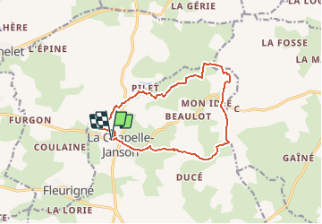
Trail Walking of 12.7 km to be discovered at Brittany, Ille-et-Vilaine, La Chapelle-Janson. This trail is proposed by neoroll44.

Description

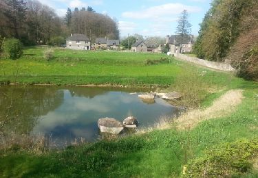
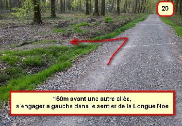
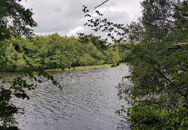
Depuis l'étang des vallées, un circuit alternant sous-bois, chemins et vues dégagées sur Fougères.

Elevation profile

Points of interest

Point of interest La Chapelle-Janson - L'étang des vallées - Photo
neoroll44
LA CHAPELLE-JANSON 

Positioning

Country:
France
Region :
Brittany
Department/Province :
Ille-et-Vilaine
Municipality :
La Chapelle-Janson
Location:
Unknown
Start:(UTM)
640454 ; 5356786 (30U) N.

Trails nearby

Trail On foot Landéan - Les Vieux Châteaux - Photo
On foot
PRO

On foot

Easy
Landéan, Brittany, Ille-et-Vilaine, France
5.3 km | 6.3 km-effort
1h 26min
Yes
Trail On foot La Chapelle-Janson - Circuit du Relais des Vallées - Photo
On foot
PRO

On foot

Easy
La Chapelle-Janson, Brittany, Ille-et-Vilaine, France
12.8 km | 15.9 km-effort
3h 36min
Yes
Trail Walking La Chapelle-Janson - GR_37_AG_21_Chapelle-Janson_Luitre-Dompierre_20210620 - Photo
Walking
patrickdanilo

Walking

Difficult
La Chapelle-Janson, Brittany, Ille-et-Vilaine, France
13.1 km | 16.2 km-effort
3h 16min
No
Trail Walking La Chapelle-Janson - GR 34 étape 3 - Photo
Walking
lagardienne

Walking

Easy
La Chapelle-Janson, Brittany, Ille-et-Vilaine, France
28 km | 34 km-effort
6h 55min
No
Trail Nordic walking Landéan - CMN Albert 10km - Photo
Nordic walking
yago1404

Nordic walking

Medium
Landéan, Brittany, Ille-et-Vilaine, France
9.9 km | 12 km-effort
1h 40min
Yes
Trail Walking Landéan - Le chemin des vieux châteaux - Photo
Walking
prv

Walking

Very easy
Landéan, Brittany, Ille-et-Vilaine, France
5.5 km | 6.5 km-effort
1h 9min
Yes
Trail Nordic walking Landéan - Fougères le 15-03-2019  - Photo
Nordic walking
toyah

Nordic walking

Very easy
Landéan, Brittany, Ille-et-Vilaine, France
7.8 km | 9.4 km-effort
1h 57min
Yes
Trail Walking Landéan - Fougères_Père Tacot - Photo
Walking
neoroll44

Walking

Easy
Landéan, Brittany, Ille-et-Vilaine, France
5.1 km | 6.2 km-effort
1h 20min
Yes
Trail Walking Beaucé - Beaucé - Photo
Walking
neoroll44

Walking

Medium
Beaucé, Brittany, Ille-et-Vilaine, France
10.7 km | 12.7 km-effort
3h 0min
Yes


Close
My subscriptions